UPDATED 1:47 P.M. JUNE 20
Early Tuesday afternoon, June 20, the National Hurricane Center upgraded Potential Tropical Cyclone Three to Tropical Storm Cindy.
The third named storm of the 2017 Atlantic hurricane season, Tropical Storm Cindy was about 265 miles south of Morgan City at 12:30 p.m. and had maximum sustained winds near 45 m.p.h., with some gusts higher.
Tropical Storm Cindy is expected to approach the coast of southwest Louisiana late Wednesday or Wednesday night, and move inland over western Louisiana and eastern Texas on Thursday, the National Hurricane Center said.
ORIGINAL STORY
By Message Staff
The entire Louisiana coast is under a tropical storm warning and is bracing for a “significant rain event Wednesday, Thursday and possibly Friday.”
In their latest update, National Weather Service officials said Potential Tropical Cyclone No.3 has become better organized since Monday but still not enough to the point of being upgraded to a tropical storm.
“The system could be classified as a tropical or subtropical cyclone later today,” the NHC said.
Depending on which expert one listens to, projected rainfall totals from the storm could produce three to five inches of rain with locally higher amounts of 10 to 15 inches in some areas.
Louisiana Baptist Disaster Relief officials, along with others, have been closely monitoring the disturbance that could possibly reach landfall in the state this week.
“This will be a rain event because we will be on the west side of the storm so everyone needs to be prepared,” said Gibbie McMillan, Louisiana Baptists state disaster relief director. “Have three days’ worth of provisions especially water — about 1 gallon per person per day; flashlights, fresh batteries, a battery-operated radio and a full tank of gas in your vehicle. Most importantly is to stay alert.”
According to the National Weather Service, a tropical storm warning is in effect from High Island, Texas, to the Mouth of the Pearl River, LA which includes Jefferson and Orange counties in southeast Texas, and Acadia, Calcasieu, Cameron, Iberia, Jeff Davis, Lafayette, St. Martin, St. Mary, Vermilion, Assumption, Lower Jefferson, Lower Plaquemines, Lower St. Bernard, Lower Terrebonne, Upper Lafourche and Upper Terrebonne parishes.
The National Weather Service plans to issue a coastal flood advisory for Jefferson County and Cameron, Iberia, St. Mary and Vermilion parishes.
If PTC 3 does become a tropical storm, residents in the affected areas can expect street flooding and some homes could also be vulnerable.
The threat of water across roads and property could impact Sabine Pass, Highway 82 west and east of Holly Beach, downtown Cameron, Pecan Island, Intracoastal City, Delcambre, Cypremort Point and Burns Point, the National Weather Service said.
Wind gusts of 40 to 60 mph are possible, especially along and south of the I-10 corridor, resulting in scattered power outages, fallen trees and minor property damage.

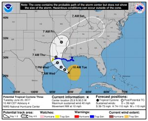
A projected path of Potential Tropical Cyclone Three shows an impact to several states in the South. National Hurricane Center photo
Gov. John Bel Edwards said after a conference call Monday that included state agencies, parish officials and first responders that statewide coordination with local and federal partners was underway.
“Now is the time to prepare for heavy rain and potentially severe weather across South Louisiana,” Edwards said in a news release. “We learned from last year’s floods that even unnamed storms can be devastating, so it is critically important for everyone in South Louisiana to get a game plan before this storm system arrives. My office, along with GOHSEP, will provide regular updates as we receive them.”
Daily GOHSEP briefings are underway with all state agencies and parishes concerning the potential tropical weather. GOHSEP has also developed a tool kit to help all citizens prepare for an emergency weather event. Citizens should visit getagameplan.org and download the new Get A Game Plan app on their smartphones.
Jim Wascom, director of the Governor’s Office of Homeland Security and Emergency Preparedness, encouraged all in the state to prepare now in advance of the storm.
“GOHSEP along with the National Weather Service encourage everyone to avoid focusing on the size of this storm as it moves across the gulf,” Waskom said. “This system may not be large, but heavy rainfall and coastal flooding are almost a certainty. Flash flooding could be a problem with the National Weather Service indicating 10-15 inches of rain possible in some areas.
“Use this time to prepare,” he continued. “Listen to information from your local leaders. Monitor your local media. Go to getagameplan.org for critical information to protect you, your family and your business. Finalize your emergency plans and check emergency supply kits now.”


