By Baptist Message Staff
All eyes are on Tropical Storm Gordon.
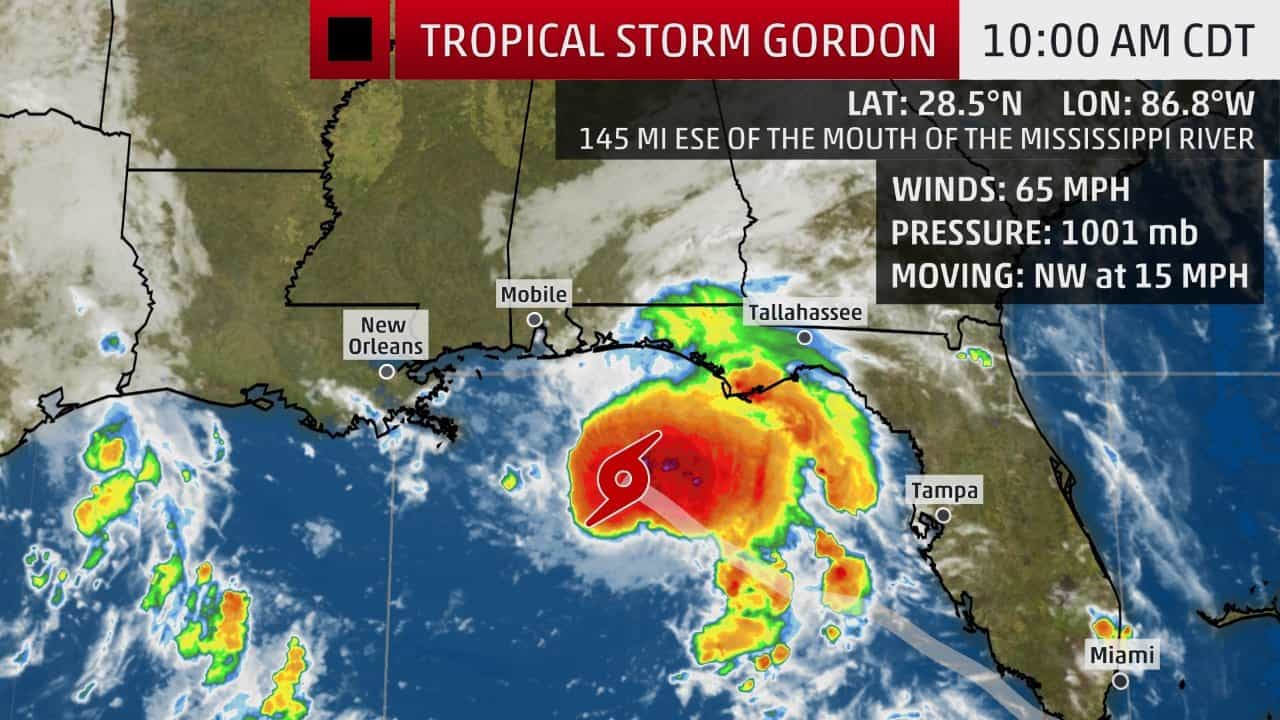
In a 10 a.m. update Tuesday, September 4, the National Hurricane Center said Gordon was moving toward the north Gulf of Mexico, and was located about 145 miles east-southeast of the mouth of the Mississippi River. Reports from separate NOAA and Air Force Reserve Unit flights monitoring the storm measured winds near 65 miles per hour with higher gusts.
Louisiana Baptist Disaster Relief officials, along with others, have been closely monitoring the disturbance.
“We are praying for the storm not to intensify,” said Gibbie McMillan, Louisiana Baptists state disaster relief director.
The New Orleans area remains under a tropical storm warning, though the warning has been discontinued for areas in Louisiana west of Grand Isle. A hurricane warning is in effect for the area from the mouth of the Pearl River to the Alabama-Florida state border.
The tropical storm warning for the area west of Grand Isle was discontinued Tuesday morning, but a tropical storm warning remains in effect from Grand Isle to the mouth of the Pearl River, including Lake Pontchartrain and Lake Maurepas. A storm surge watch is still in effect for the areas west of Shell Beach to the mouth of the Mississippi River.
A relatively compact system with most of its “convective banding” east of the center of circulation, will make landfall late Tuesday night along the Mississippi Gulf Coast as a Category 1 hurricane, the National Hurricane advised in its 10 a.m. Tuesday update.
With max winds at 65 miles per hour, Gordon is about 145 miles east-southeast of the mouth of Mississippi River and moving quickly toward the west-northwest at 15 mph, the NHC said in its 10 a.m. update.
On the forecast track, the center of Gordon will move across the eastern Gulf of Mexico on Tuesday and will approach the north-central Gulf Coast within the warning area late Tuesday afternoon or evening and move inland over the lower Mississippi Valley late Tuesday and early Wednesday.
The storm is expected to rapidly weaken once it moves inland and then move towards the northwest.
State preparedness
Louisiana Gov. John Bel Edwards issued a state of emergency declaration late Monday ahead of any potential impact by Gordon.
According to a news release by the Governor’s Office of Homeland Security, Edwards and state officials began participating in calls with the National Weather Service last weekend, and activated the GOSHEP Crisis Action Team Saturday.
Edwards also has authorized the activation of 200 Louisiana National Guardsmen to be pre-positioned along with 63 high water vehicles, 39 boats and four helicopters. They will be pre-positioned primarily in Southeast Louisiana.
“As we continue to monitor Tropical Storm Gordon’s path there is a strong possibility that Louisiana could be impacted by flooding, storm surges and strong winds, and we want to make certain that help is made available to them as quickly as possible,” Edwards said.
“We are in constant communication with parish officials assessing their needs and readiness to address issues related to the storm, and we are prepared to provide them with additional assistance if needed,” Edwards continued. “We are urging all citizens to continue paying close attention to their local officials and weather forecasts for updates over the next 24 hours.”
Schools through Southeast Louisiana, including New Orleans Baptist Theological Seminary, took a proactive approach and called off Tuesday classes. New Orleans Mayor LaToya Cantrell issued voluntary evacuation orders for areas outside the levee systems, including Venetian Isles, Lake Catherine and Irish Bayou communities.
“Because of the combined threat of existing coastal flooding and the increased surge from Gordon, I’m asking residents outside of the levee protection system to exercise extreme caution,” Cantrell said during a news conference Monday.
Rainfall estimates for south Louisiana have decreased as the storm’s track has come into sharper focus. The National Weather Service’s Weather Prediction Center projects 1-4 inches of rain, with locally higher amounts, for south Louisiana through Thursday morning.